


Dujiangyan Irrigation System in Chengdu

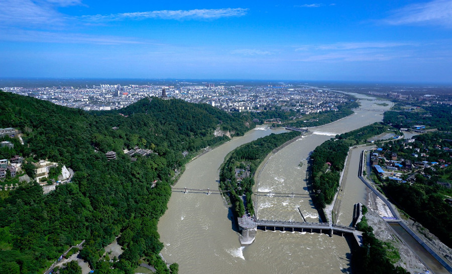
Dujiangyan Irrigation System is a pearl in the irrigation work of ancient China,and it's the oldest and the only preserved grand irrigation system in the world. Built over 2,200 years ago, Dujiangyan Irrigation System still provides benefits to people. The irrigation system was built on the Minjiang River at the foot of Yulei Mountain, northwest of Dujiangyan City in Sichuan Province.
Type: Irrigation System, nature attractions, historic spot
Best Time to Visit: All year round
Chinese Name: 都江堰 (Du Jiang Yan)
Recommended Visiting Time: one day
Open Hours:
Winter (December 1 - March 1): 8: 00-17: 30
Other seasons (March 2 - November 30): 8: 00-18: 00
Admission Fee:90 RMB / Person
Address: On the Minjiang River, west of Chengdu Plain, Dujiangyan City, Chengdu, Sichuan Province(四川省成都市都江堰市城西,坐落在成都平原西部的岷江上)
Dujiangyan Irrigation System is a pearl in the irrigation work of ancient China, and it’s the oldest and the only preserved grand irrigation system in the world, which has no dam for water-diversion and still in service today. The system was built in 256 of Qin Dynasty (221BC-206BC) under the leadership of Li Bing (李冰, the chief official of ancient Chengdu) and his son. Built over 2,200 years ago, Dujiangyan Irrigation System still provides benefits to the area, and it’s fame Tian Fu Zhi Guo (天府之国, means “country of heaven” or “land of abundance”).
In 256 BC during the Warring States period (战国时期), Li Bing (李冰), the governor of Shu Commandery (蜀郡) under the Qin State (秦国), led the construction of the Dujiangyan Irrigation System (都江堰水利工程). It is located on the Min River (岷江) to the west of Dujiangyan City (都江堰市) in the Chengdu Plain (成都平原), about 56 kilometers from Chengdu (成都).
Project Overview
The Dujiangyan Irrigation System remains in use today, continuously irrigating farmland and serving the people. It is a great water conservancy project known for its long history and dam-free water diversion method, often regarded as the origin of the world’s water conservancy culture.
The project consists of three main parts:
- Fish Mouth Levee (鱼嘴分水堤) — for water diversion
- Flying Sand Weir (飞沙堰) — for flood discharge
- Bottle-Neck Channel (宝瓶口) — for water intake
Additionally, there are auxiliary projects such as the Baizhang Dyke (百丈堤) and Renzi Dyke (人字堤).
Technical Innovations
The project scientifically addresses the following issues:
- Automatic water diversion: The Fish Mouth Levee (鱼嘴分水堤) splits the water into a 60:40 ratio — 60% flows into the Inner River (内江) for irrigation, while 40% flows into the Outer River (外江) for flood discharge.
- Automatic sand discharge: The Fish Mouth Levee (鱼嘴分水堤) separates sand and water at an 80:20 ratio — 80% water and 20% sand are discharged.
- Water flow control: The Bottle-Neck Channel (宝瓶口) and Flying Sand Weir (飞沙堰) regulate the intake of water, preventing flooding and ensuring proper distribution.
Impact and Legacy
By 1998, the irrigation area reached 668,700 hectares and covered more than 40 counties.
To honor Li Bing (李冰) and his son, the Erwang Temple (二王庙), also known as the Temple of the Two Kings, was built.
In 2018, the Dujiangyan Irrigation System (都江堰水利工程) was included in the World Irrigation Engineering Heritage List (世界灌溉工程遗产名录).
Basic Information
- Chinese name: Dujiangyan Irrigation System (都江堰水利工程)
- Established: 256 BC
- Type: Water conservancy project
- Main components: Fish Mouth Levee (鱼嘴分水堤), Flying Sand Weir (飞沙堰), Bottle-Neck Channel (宝瓶口)
- Founder: Li Bing (李冰)
- Engineering technique: Midstream weirs (中流作堰)
- River: Min River, a major tributary of the upper Yangtze River (都江堰长江上游的一大支流)
- Function: Eliminate flood hazards and other natural risks (消除水害等自然隐患)
- Modern management: Dujiangyan Water Resources Dispatching Center (都江堰水利调度中心)
Features of Dujiangyan Irrigation System
- World Cultural Heritage (listed by UNESCO as “World Cultural Heritage” in 2000)
- World Natural Heritage (Giant Panda Habitats in Sichuan Province)
- National Key Cultural Relics Protection Unit
- National Scenic Area
- National AAAAA Tourism Scenic Area
Background
The Chengdu Plain (成都平原), known as the “Land of Abundance” (天府之国), was historically plagued by both floods and droughts. The famous poet Li Bai (李白) lamented these natural disasters in his poem The Hard Road to Shu (Shu Dao Nan, 《蜀道难》), writing:
“Silkworm Bush and Fish Hawk founded the kingdom, how vast and mysterious it seems.”
“People may become fish and turtles.”
These lines vividly depict the harsh reality of ancient times, shaped by the unforgiving natural conditions of the Min River (岷江) and the Chengdu Plain.
The Min River (岷江), a major tributary of the upper Yangtze River (长江), flows through the western part of the Sichuan Basin (四川盆地), a region with heavy rainfall. The river originates from the southern slopes of the Min Mountains (岷山) at the Sichuan-Gansu border, with two sources — the East Source from Gonggang Ridge (弓杠岭) and the West Source from Langjia Ridge (郎架岭). These two sources converge at Wuba (无坝) in Songpan County (松潘县).
The Min River flows southward through Songpan County (松潘县), Dujiangyan City (都江堰市), and Leshan City (乐山市), eventually joining the Yangtze River at Yibin City (宜宾市). Spanning 793 kilometers, with a drainage area of 133,500 square kilometers, the river has an average gradient of 4.83‰ and an annual water flow of about 15 billion m³.
The Min River is divided into three sections:
- Upper reaches: Above Dujiangyan (都江堰), known for timber floating and hydropower.
- Middle reaches: From Dujiangyan City (都江堰市) to Leshan (乐山), forming the Dujiangyan Irrigation District (都江堰灌区) along with the Tuo River system (沱江水系) and artificial river networks.
- Lower reaches: Below Leshan (乐山), primarily used for navigation.
With over 90 tributaries, the Min River’s right bank, fed by steep mountain ranges, contributes most of its water, leading to rapid rises and falls during the rainy season, resulting in strong and swift currents.
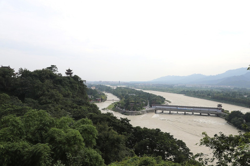
The river exits the Min Mountains (岷山) and flows south along the western side of the Chengdu Plain (成都平原), forming a high “hanging river” above the plain. The elevation drops sharply from the Yulei Mountain (玉垒山) at the mountain’s exit to Chengdu — a 273-meter descent over a mere 50 kilometers.
In ancient times, floods would often turn the plain into a vast expanse of water, while droughts would parch the land. The constant flooding and drought posed a major obstacle to the survival and development of the ancient Shu Kingdom (古蜀国).
Historical Background of Dujiangyan
The creation of the Dujiangyan Irrigation System (都江堰) also has a historical foundation. During the Warring States period (战国时期), wars were rampant, and people longed for peace and unity. At this time, the State of Qin (秦国) grew stronger due to Shang Yang’s reforms (商鞅变法). Recognizing the strategic importance of the Shu region (蜀国), Prime Minister Sima Cuo (司马错) famously said:
“He who conquers Shu will conquer Chu; once Chu falls, all under heaven will unite.”
Against this backdrop, King Zhao of Qin (秦昭王) appointed Li Bing (李冰) — an expert in astronomy and geography — as the governor of Shu. Determined to control the Min River’s flooding, Li Bing sought to develop agriculture in western Sichuan and strengthen the economic foundation for Qin’s unification of China.
The effective management of Dujiangyan has ensured its continued function for over two millennia. During the reign of Emperor Ling of Han (汉灵帝), officials called “Du Shui Zhuan” (都水椽) and “Du Shui Zhang” (都水长) were appointed to oversee the irrigation system. Zhuge Liang (诸葛亮) of the Shu Han Kingdom (蜀汉) established water officials and organized a workforce of 1,200 people to maintain the system (Shui Jing Zhu, 《水经注·江水》).
In the Song Dynasty (宋朝), a vital “Annual Repair System” (岁修制度) was formalized, which continues to this day.
The Structure of Dujiangyan
Dujiangyan is an extensive hydraulic engineering project consisting of:
- The headworks (渠首枢纽) — controlling the Min River’s water flow.
- Irrigation channels (灌区各级引水渠道) — distributing water across the Chengdu Plain.
- Supporting buildings (各类工程建筑物) — aiding water management.
- Reservoirs and ponds (大中小型水库和塘堰) — for water storage and flood control.
The system irrigates over 10 million mu (about 667,000 hectares) of farmland across 7 cities and 36 counties in western Sichuan, supplying water for more than 50 key enterprises and residents in Chengdu. It also serves multiple purposes, including flood control, hydroelectric power, water transportation, aquaculture, forestry, tourism, and environmental protection.
As of May 2023, Dujiangyan’s irrigation area accounts for:
- 1/20 of Sichuan’s land area
- 1/4 of the province’s effective irrigation and grain output
- 1/3 of Sichuan’s population
- Nearly half of the province’s GDP
It is the largest and most economically vital irrigation district in Sichuan, forming the economic backbone of the Chengdu metropolitan area and its surrounding economic circle.
Management of Dujiangyan
After the founding of the People’s Republic of China, Dujiangyan expanded rapidly. The government established dedicated administrative bodies:
- 1950: Sichuan West Dujiangyan Administration Office (川西都江堰管理处)
- 1952: Renamed as the Sichuan Provincial Water Resources Department Dujiangyan Administration Office (四川省人民政府水利厅都江堰管理处)
- 1955: Further renamed as the Sichuan Provincial Water Resources Department Dujiangyan Administration Office (四川省水利厅都江堰管理处)
- 1958: Renamed as Dujiangyan Administration Office (都江堰管理处)
- 1978: Sichuan Provincial Dujiangyan Administration Bureau (四川省都江堰管理局)
Currently, the bureau consists of 17 departments, including offices for supply operations, industrial water use, engineering management, scientific research, and financial affairs.
Annual Repair System
The Annual Repair System (岁修制度) ensures the continuous operation of Dujiangyan. Introduced during the Song Dynasty, it mandates that repairs be conducted during the dry season (winter to spring) when farming is less active. This process, known as “Chuan Tao” (穿淘), involves:
- Reinforcing embankments
- Dredging river channels
The depth of dredging is determined by reaching the “Stone Horse” (石马) buried at the bottom of the riverbed, while the height of the embankments aligns with the water level markers on the opposite rock face.
Since the Ming Dynasty, “Iron Sleepers” (卧铁) have replaced the Stone Horse as depth markers. Today, three iron sleepers — each 10 feet long — remain on the left bank of Baopingkou (宝瓶口), cast during the Ming Wanli period (明万历年间), Qing Tongzhi period (清同治年间), and in 1927.
Location of Dujiangyan Irrigation System
The irrigation system was built on the Minjiang River at the foot of Yulei Mountain, northwest of Dujiangyan City and west of Chengdu Plain in Sichuan Province.
Background & History of Dujiangyan Irrigation System
Background
Dujiangyan Irrigation System was built on Minjiang River, which is a large tributary of Yangtze River and flows through the west of Sichuan Basin, an area of heavy rainfall. In ancient time, during flood period, the Chengdu Plain was just a world of waters while during drought period, it was a scene of utter desolation; generally, there was no single grain was reaped in a year and people lived around often suffer from hunger. To solve the livelihood of Chengdu people and because of its specific strategic position in unifying of China, the Qin Kingdom (770BC-221BC) appoint Li Bing, a wisdom who had good knowledge of astronomy and geography, to control the flood and had the Dujiangyan Irrigation System build.
Planning
Li Bing investigated the problem and discovered that the river was swelled by fast flowing spring melt-water from the local mountains that burst the banks when it reached the slow moving and heavily silted stretch below. One solution would have been to build a dam but Li Bing had also been charged with keeping the waterway open for military vessels to supply troops on the frontier, so instead he proposed to construct an artificial leeve to redirect a portion of the river’s flow and then to cut a channel through Mount Yulei to discharge the excess water upon the dry Chengdu Plain beyond.
Construction
Li Bing received 100,000 taels of silver for the project from King Zhao of Qin and set to work with a team said to number tens of thousands. The levee was constructed from long sausage-shaped baskets of woven bamboo filled with stones known as Zhulong held in place by wooden tripods known as Macha. The construction of a water-diversion levee resembling a fish’s mouth took four years to complete.
Cutting the channel proved to be a far greater problem, as the tools available to Li Bing at the time, before gunpoder was invented, could not penetrate the hard rock of the mountain, so he used a combination of fire and water to heat and cool the rocks until they cracked and could be removed. After eight years of work, a 20-metre-wide (66 ft) channel had been gouged through the mountain.
 Dujiangyan Irrigation System
Engineering Constructions
Li Bing’s Irrigation System consists of three main constructions that work in harmony with one another to ensure against flooding and keep the fields well supplied with water:
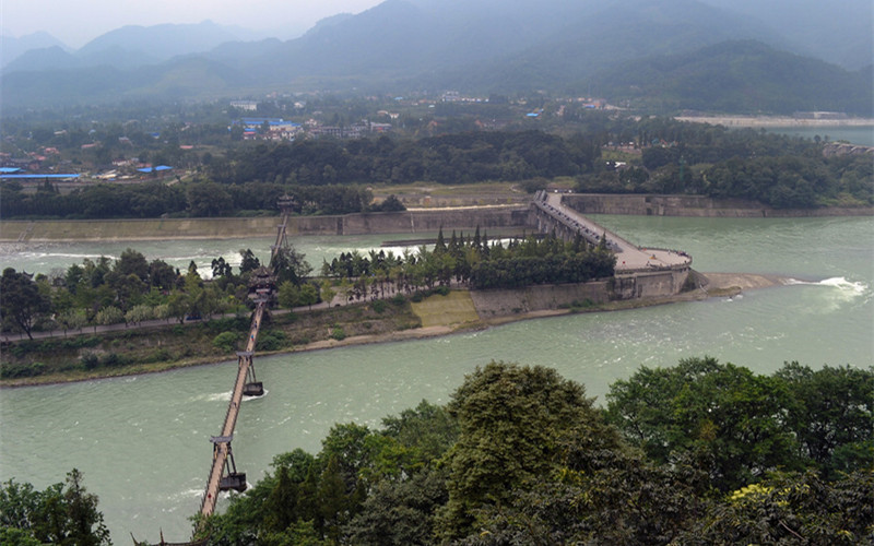
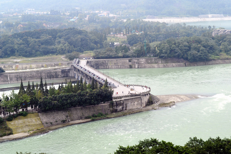
- The Yuzui or Fish Mouth Levee(鱼嘴), named for its conical head that is said to resemble the mouth of a fish, is the key part of Li Bing’s construction. It is an artificial levee that divides the water into inner and outer streams. The inner stream is deep and narrow, while the outer stream is relatively shallow but wide. This special structure ensures that the inner stream carries approximately 60% of the river’s flow into the irrigation system during dry season. While during flood, this amount decreases to 40% to protect the people from flooding. The outer stream drains away the rest, flushing out much of the silt and sediment.
- The Feishayan or Flying Sand Weir(飞沙堰) has a 200 m-wide opening that connects the inner and outer streams. This ensures against flooding by allowing the natural swirling flow of the water to drain out excess water from the inner to the outer stream. The swirl also drains out silt and sediment that failed to go into the outer stream. A modern reinforced concrete weir has replaced Li Bing’s original weighted bamboo baskets.
- The Baopingkou or Bottle-Neck Channel(宝瓶口), which Li Bing gouged through the mountain, is the final part of the system. The channel distributes the water to the farmlands in the Chengdu Plain, whilst the narrow entrance that gives it its name, works as a check gate, creating the whirlpool flow that carries away the excess water over Flying Sand Fence, to ensure against flooding.
History
Origin of the Name
When Li Bing (李冰), the governor of Shu Commandery of the Qin State, first built the dam, Dujiangyan was initially called “Jianpeng” (湔堋). This name originated from Mount Yulei (玉垒山), which was called “Jian Mountain” (湔山) before the Qin and Han dynasties. The Diqiang people (氐羌人), the main ethnic group living around Dujiangyan at the time, referred to dams as “Peng” (堋), thus giving rise to the name “Jianpeng” (湔堋).
During the Three Kingdoms period, under the Shu Han regime, Du’an County (都安县) was established in the Dujiangyan area, so the irrigation system was called “Duan Dam” (都安堰). It was also known as “Golden Dike” (金堤) to highlight the function of the Yuzui (鱼嘴) Water-Dividing Dyke, using “dike” instead of “dam” as part of its name.
In the Tang dynasty, Dujiangyan was renamed “Jianwei Dam” (楗尾堰). The name reflected the materials and methods used for dyke construction at the time, mainly “breaking bamboo into cages, with a round diameter of three feet, filling them with stones, stacking them to block the water” — using stone-filled bamboo cages, referred to as “Jianwei” (楗尾).
It wasn’t until the Song dynasty that the name “Dujiangyan” appeared in historical records. The “Song History” (宋史) states: “The Yongkang Army repairs Dujiangyan annually, uses stone cages to control the river and block water, and irrigates the fields of several counties.” According to the “Shu Water Investigation” (蜀水考), “The Fu River (府河), also known as Chengdu River (成都江), has two sources, namely Pi River (郫江) and Liu River (流江).” The upstream of these rivers, Baitiao River (柏条河) and Zouma River (走马河), branched from the inner flow of Dujiangyan. Since the Song dynasty, the entire Dujiangyan water conservancy system began to be collectively referred to as “Dujiangyan” (都江堰), accurately representing the entire hydraulic system — a name still used today.
Construction and Engineering
In 256 BC, during the reign of King Zhaoxiang of Qin (秦昭襄王), Li Bing (李冰), the governor of Shu Commandery (蜀郡), led the people of Shu to build the immortal Dujiangyan Irrigation System. This project took full advantage of the region’s geographical feature — higher in the northwest and lower in the southeast — and adapted to the unique topography, watercourses, and water flow at the mountain outlet.
By channeling water without using a dam, Dujiangyan allowed for natural flow irrigation. It combined flood control, water division, sand discharge, and flow regulation into an interconnected system, ensuring comprehensive benefits for flood prevention, irrigation, water transport, and domestic water use.
The most remarkable aspect of Dujiangyan is its enduring functionality for over two millennia. Since 1936, with advancements in science and technology and the expansion of the irrigation area, the headworks of the system have undergone repairs and reinforcements using concrete-rubble masonry techniques, adding modern hydraulic facilities.
Despite these updates, the ancient dam’s layout and water management strategies — “deepening the shoals and lowering the dam” (深淘滩、低作堰), “adapting to natural conditions and adjusting to the time” (乘势利导、因时制宜), and “cutting corners at bends and hollowing out straight sections” (遇湾截角、逢正抽心) — have remained unchanged.
With its long history, massive scale, advanced technology, vast irrigation area, and significant socio-economic benefits, Dujiangyan has gained worldwide fame and has become a model for water resource utilization globally.
Historical Events
Sima Qian’s Investigation of Dujiangyan
In 111 BC, during the reign of Emperor Wu of the Han Dynasty (汉武帝), the great historian Sima Qian (司马迁) conducted a field investigation of Dujiangyan while on a diplomatic mission to the southwest. He documented Li Bing’s achievements in creating Dujiangyan in the “Records of the Grand Historian: Book of Canals” (史记·河渠书). To commemorate this, later generations built the Xizhan Pavilion (西瞻亭) and Xizhan Hall (西瞻堂) near Mount Min (岷山) and Lidui (离堆).
Zhuge Liang’s Military Protection of Dujiangyan
In 228 AD, during the reign of Emperor Liu Shan of Shu Han (蜀汉), Prime Minister Zhuge Liang (诸葛亮) recognized Dujiangyan as the foundation of agriculture and a crucial pillar of the national economy. He mobilized 1,200 soldiers to guard the irrigation system and appointed dedicated water officials for its maintenance. This set a precedent for assigning specialized water conservancy officials to manage Dujiangyan throughout subsequent dynasties.
Zhang Ling’s Daoist Teachings at Mount Qingcheng
Between 126–144 AD, during the reign of Emperor Shun of the Eastern Han Dynasty (东汉顺帝), Zhang Ling (张陵) traveled from Luoyang over the Qin Mountains to practice Daoism at Heming Mountain (鹤鸣山). In 143 AD, he and his disciples moved to Mount Qingcheng (青城山) to preach Daoism.
Zhang Ling spent 13 years spreading Daoism in the Qingcheng mountainous region and passed away at the Third Mixed Yuan Peak (第三混元顶) in 156 AD. Mount Qingcheng became the birthplace of the Celestial Master Dao (天师道), with Changdao Temple (常道观) honored as “the wondrous place of celestial secrets and the blessed land of prosperity.” Celestial Masters from Dragon and Tiger Mountain (龙虎山) frequently visited Mount Qingcheng to pay homage to Zhang Ling’s tomb. A rare ancient ginkgo tree beside the Tianshi Cave (天师洞) — so large that it takes seven or eight people to encircle it — is said to have been planted by Zhang Ling himself.
Marco Polo’s Visit to Dujiangyan
Between 1264–1294 AD, during the reign of Kublai Khan (元世祖至元年间), the famous Italian traveler Marco Polo (马可·波罗) rode from Hanzhong (汉中) in Shaanxi Province to Chengdu, taking over 20 days. He visited Dujiangyan and recorded in his “The Travels of Marco Polo” (马可·波罗游记):
“The Dujiang River flows swiftly, rich with fish, and bustling with boats transporting goods up and downstream.”
Ferdinand von Richthofen’s Study of Dujiangyan
Between 1862–1874 AD, during the reign of the Tongzhi Emperor (清同治年间), German geographer Ferdinand von Richthofen (李希霍芬) visited Dujiangyan. With his professional insight, he highly praised the perfection of Dujiangyan’s irrigation methods, declaring it unmatched anywhere in the world.
In 1872, Richthofen dedicated a chapter to Dujiangyan in his “Letters from Baron von Richthofen” (李希霍芬男爵书简), becoming the first person to introduce Dujiangyan in detail to the Western world. He praised:
“The perfection of Dujiangyan’s irrigation methods is unparalleled anywhere in the world.”
Main Attractions of Dujiangyan Irrigation System
Erwang Temple (Two Kings Temple)
Located on the hillside of south bank of Minjiang River, the Erwang Temple just faces the Dujiangyan Irrigation System. It was originally an ancestral temple in memory of Shu King which later was changed to commemorate Li Bing and his son during Jianwu Period (494-498) of Qi Dynasty (479-502) during Southern Dynasties (420-589). In Song Dynasty (960-1279), Li Bing and his son were awarded as kings in succession by Song emperors, hence the name Two Kings Temple. In the temple are enshrined statues of Li Bing and his son, valuable famous remarks about water control and tablet inscriptions given by poets.
Fulong Temple (Unawakened Dragon Temple)
Fulong Temple is located in Lidui Park and faces a pool below. Legend has it that during his flood control, Li Bing had subdued a dragon and had it under the Lidui. The existing temple is consists of three halls, the front of which possesses a Stone Statue of Bi Bing built in Eastern Han Dynasty (25-220). In the temple, there is also a precious remain of female Taoism priests Jinxian and Yuzhen (both are princesses of Tang Dynasty (618-907)), the Feilong Ding (Flying Dragon Ding, an ancient cooking vessel).
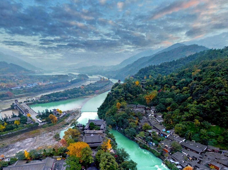
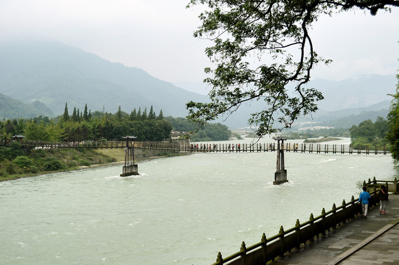
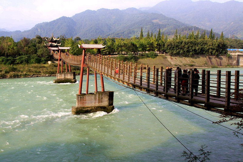
Anlan Suspension Bridge(Couple Bridge)
Annan Bridge is located on Fish-mouth Dyke of Dujiangyan Irrigation System and stretches across both inside and outside rivers. It is hailed as one of the Five Bridges of Ancient China and is the most characteristic landscape of Dujiangyan. The previous bridge was built before Song Dynasty which was unfortunately destroyed in the war in late Ming Dynasty (1368-1644), and during the rein of Jiaqing (1796-1820) in Qing Dynasty (1644-1911), Anlan Suspension Bridge was rebuilt with woods supported by stone piers and for a length of 500 meters.
Zipingpu Water Conservancy Project
The Zipingpu Water Conservancy Project (紫坪铺水利工程) is located on the upper reaches of the Min River (岷江), about 9 kilometers northwest of Dujiangyan City (都江堰市). The Min River (岷江) is a primary tributary of the Yangtze River (长江), originating from the southern slopes of Min Mountain (岷山) at the border of Sichuan (四川) and Gansu (甘肃). It flows through Mao County (茂县), Wenchuan County (汶川县), Dujiangyan City (都江堰市), and the southern Chengdu Plain (成都平原), merging with the Dadu River (大渡河) and Qingyi River (青衣江) in Leshan (乐山) before joining the Yangtze River (长江) in Yibin (宜宾).
The Min River (岷江) has a total length of 711 kilometers and a drainage area of 135,881 square kilometers. The upper reaches are rich in water resources, mainly fed by rainfall, groundwater, and melting snow from the mountains. The flood season occurs annually from June to September.
Hydropower and Development
Several hydropower stations have been built along the Min River (岷江), including:
- Yuzi Creek Hydropower Stations I and II (鱼子溪一、二级电站)
- Yingxiu Bay Hydropower Station (映秀湾电站)
- Taipingyi Hydropower Station (太平驿电站)
- Futangba Diversion Power Station (福堂坝引水式电站)
However, these stations primarily generate electricity without supplying water. To fully develop the Min River’s (岷江) water resources, ease the water and electricity shortages in the Chengdu Plain (成都平原), and promote sustainable economic growth in Sichuan Province (四川省), the Zipingpu Water Conservancy Project (紫坪铺水利工程) was launched:
- Approved by the State Council (国务院) and the National Development and Reform Commission (国家发展计划委员会) in March 2003.
- Listed as one of the Ten Major Projects of Western Development (西部大开发十大标志性工程) by the Ninth National People’s Congress (全国人大九届三次会议).
- The Ministry of Water Resources (水利部) approved the preliminary design in December 2000.
- Construction began in February 2001.
Project Details
The Zipingpu Water Conservancy Project (紫坪铺水利工程) is a large-scale multi-purpose water conservancy hub focused on irrigation and water supply, while also supporting power generation, flood control, environmental protection, and tourism.
Key milestones:
- River closure in November 2002.
- First generator unit began operation on November 1, 2005.
- Project completed in December 2006.
The total investment:
- Static investment: 6.433 billion yuan
- Total investment: 6.976 billion yuan
Major Structures
The hub consists of:
- Main dam (大坝): Reinforced concrete-faced rockfill dam
- Maximum dam height: 156 meters
- Spillway (溢洪道)
- Water diversion and power generation system (引水发电系统)
- Sand flushing and emptying tunnel (冲砂放空洞)
- Flood discharge and sand flushing tunnels No.1 and No.2 (1#泄洪排砂洞, 2#泄洪排砂洞)
Reservoir Specifications
- Total reservoir capacity: 1.112 billion cubic meters
- Flood control storage capacity: 538 million cubic meters
- Regulating storage capacity: 774 million cubic meters
- Normal water storage level: 877 meters
- Flood season restricted water level: 850 meters
- Flood peak flow (once in 1,000 years): 12,700 cubic meters per second
- Corresponding reservoir capacity: 998 million cubic meters
- Reservoir area: 18.16 square kilometers
- Backwater length: 26.5 kilometers
Power Generation
- Installed capacity: 4 sets of 190MW hydroelectric generator units
- Total installed capacity: 760MW
- Annual average power generation: 3.417 billion kWh
Benefits
The Zipingpu Water Conservancy Project (紫坪铺水利工程) enhances:
-
Irrigation:
- Boosts the irrigation water supply for 10.08 million mu (亩) of farmland in the Dujiangyan Irrigation District (都江堰灌区) during the dry season.
- Increases water supply by 437 million cubic meters annually during dry periods.
- Ensures irrigation for an additional 3.14 million mu (亩) of farmland in adjacent districts.
-
Water Supply:
- Supplies 20 cubic meters per second of environmental water for Chengdu (成都市).
- Increases Chengdu’s water supply capacity from 28 cubic meters per second to 50 cubic meters per second.
- Adds an annual water supply of 300 million cubic meters.
-
Flood Control:
- Reduces the peak flood flow from a once-in-100-years flood to a once-in-10-years flood in the upper Min River (岷江), effectively mitigating flood threats along the Jinma River section (金马河段).
-
Power Generation:
- Supplies economic peak-shaving and frequency-regulation power to the Western Sichuan Power Grid (川西电网).
-
Environmental Protection:
- Regulates the Min River’s (岷江) water flow.
- Protects the Dujiangyan Irrigation System (都江堰灌溉系统) from sediment damage.
The Zipingpu Water Conservancy Project (紫坪铺水利工程) effectively regulates the Min River’s (岷江) water resources, expands the Dujiangyan Irrigation District (都江堰灌区), and ensures reliable water supply and electricity for the Chengdu Plain (成都平原). It significantly improves flood control standards for the midstream Min River and Chengdu Plain, playing a crucial role in the region’s sustainable social and economic development.
Investment
- Dynamic Investment: 7.2 billion RMB
- Static Investment: 6.2 billion RMB
Project Components
The Dujiangyan Irrigation System is primarily composed of three major engineering projects: Yuzui (鱼嘴), Feisha Weir (飞沙堰), and Baopingkou (宝瓶口). These three components work in coordination to regulate the flow of water, control floods, and provide irrigation. The system is designed with the function of “dividing water into four parts, balancing drought and flood.”
Yuzui (鱼嘴) Dividing Weir
The “Yuzui” is the water dividing structure of the Dujiangyan system, named because it resembles the shape of a fish’s mouth. It is located at the center of the Minjiang River (岷江), dividing the river into two channels. The western channel, called Waijiang (外江) or “Golden Horse River,” carries the primary flow of water for flood discharge. The eastern channel, Neijiang (内江), is a man-made irrigation channel used to transport water for agricultural irrigation.
Feisha Weir (飞沙堰)
Known for its flood discharge and sediment removal functions, Feisha Weir (飞沙堰) is one of the key components of the Dujiangyan system. Despite its seemingly simple appearance, it plays a crucial role in protecting the Chengdu Plain from flooding. When the water in Neijiang (内江) exceeds the flow capacity of Baopingkou (宝瓶口), the excess water automatically overflows from Feisha Weir (飞沙堰). During extreme floods, the weir can even collapse to allow large amounts of water to return to the Minjiang River. Additionally, it helps remove sediment from the river, preventing blockages that could affect irrigation.
Baopingkou (宝瓶口)
Baopingkou (宝瓶口) serves as the control sluice, controlling the water flow into the Neijiang (内江) channel. Carved into the long ridge of Yulei Mountain (玉垒山), Baopingkou (宝瓶口) resembles the neck of a bottle, giving it its name. The mountain area on the right side of the Baopingkou (宝瓶口) is called Lidui (离堆). Before the construction of Baopingkou (宝瓶口), Lidui (离堆) was part of Jianshan Hutou Rock (湔山虎头岩). The Baopingkou (宝瓶口) and its natural beauty have been celebrated as one of the Ten Scenic Views of Duanyang (灌阳十景).
History and Creation of Dujiangyan
In 256 BC, during the reign of King Zhao of Qin (秦昭襄王), Li Bing (李冰) was appointed as the governor of Shu Commandery (蜀郡太守) and oversaw the construction of Dujiangyan to resolve flooding issues and irrigate the Chengdu Plain. The project divided the Minjiang River into two flows, one of which was redirected to irrigate the plain, reducing flood damage and promoting agriculture.
Li Bing and his son Er Lang (二郎), along with skilled farmers, worked together to dig through Yulei Mountain (玉垒山), a process that involved heating the rocks to make them crack, as explosives were not available at the time. They created a tunnel 20 meters wide, 40 meters high, and 80 meters long. This tunnel, resembling the neck of a bottle, was named Baopingkou (宝瓶口), and the stone piles left behind were named Lidui (离堆).
Key Features of Dujiangyan
The most notable feature of Dujiangyan is its ability to regulate water without the use of dams, allowing for sustainable and natural flood control. The entire irrigation system includes multiple weirs, reservoirs, and channels such as the People’s Canal (人民渠), Dongfeng Canal (东风渠), Sanhe Weir (三合堰), and Tongji Weir (通济堰), all contributing to the region’s water management. The surrounding natural scenery is equally stunning, with landmarks like Hulong Temple (伏龙观), Erwang Temple (二王庙), Anlan Suspension Bridge (安澜索桥), and Lidui Park (离堆公园).
Cultural Environment
The Dujiangyan Irrigation System is not only a marvel of ancient Chinese engineering but also plays a key role in the local culture and economy. The area around Dujiangyan has been known as the Tianfu (天府) or “Land of Abundance,” owing to its fertile soil and rich history. The irrigation system is integral to the prosperity of the Sichuan Province, the economic and cultural heart of the region.
Modern Application of Dujiangyan
The Dujiangyan Irrigation System continues to function as a vital water resource for the Chengdu Plain. In recent years, efforts have been made to preserve and maintain the system, using traditional methods to manage water flow and ensure the longevity of the irrigation channels.
In September 2024, the Dujiangyan Water Conservancy Development Center (都江堰水利发展中心) reported that the system had successfully transported over 1.2 billion cubic meters of water to provide relief from the high summer temperatures, showcasing the continued relevance of this ancient engineering marvel.
How to Get to Dujiangyan Irrigation System
Travel with ChinaDragonTours (top recommended)
If you want to get rid of hustle of transportation and troublesome navigation, you can book a private tour package which covers visiting, dining and transfer from us. Our local tour guide and driver will escort you to Dujiangyan Panda Base with speed and convenience, and take care of all the details. You just need to focus on visiting.
Independent Travel
For Independent travelers you can
- By Coach: If you choose to take a bus from Chengdu to Dujiangyan, Chadianzi Bus Station is the main tourism station to Dujiangyan Bus Station. Usually it takes about 1 hour to get to Dujiangyan Bus Station. The ticket fare is about 17RMB. Then you can take a bus or taxi to the scenic spots.
- By CRH: Since 2003, the Intercity High-speed train from Chengdu to Dujiangyan has become the convenient and comfortable way to Dujiangyan. There are 21 bullet trains every day from Chengdu (North)Railway Station or Xipu Station to Dujiangyan Railway Station. The ticket will cost 15RMB. The earliest one starts at 06:02 and the last one start at 21:19. Usually it takes about half an hour to arrive at Dujiangyan Train Station. After arriving at Dujiangyan Railway Station, you can take a bus or taxi to scenic spots.
Read more about Dujiangyan Transportation.
 Dujiangyan Irrigation System
Recommended Tour Route in Dujiangyan Scenic Area
Route 1:
Lidui Park – Fulong Temple – Precious Bottle Neck – Feisha Weir – Fish Mouth – Anlan Rope Bridge – Two Kings Temple
Route 2:
Xingfu Road- South Bridge – Lidui Park – Fish Mouth – Rope Bridge – Two Kings Temple – Li Bing Memorial Hall – Buyun Veranda – Yulei Pavilion – Ancient City Wall – Douxi Pavilion – Town God’s Temple – West Street – South Street – Confucious’ Temple Park
Accommodation
Being a popular tourist destination around Chengdu, Dujiangyan offers different star-rated hotels for travelers, ranging from 5-star hotel to budget hotel. You can choose where to stay in accordance with your requirements and budgets. Some visitors prefer to stay around Mount Qingcheng.
Please read more about Dujiangyan Accounmondation.
Nearby Attractions
Qingcheng Mountain
Qingcheng mountain is the birthplace of Chinese Taoism which is divided into two parts: the front mountain and back mountain. If you want to explore the most essential elements of Taoism culture, the front mountain is the best choice, while if you like to climb mountains and enjoy the natural scenery, the back mountain is better.
Dujiangyan Panda Base
China Conservation and Research Centre for the Giant Panda (CCRCGP), Dujiangyan Base (中国大熊猫保护研究中心都江堰基地) is a brand new giant panda breeding base in Chengdu. You can hold a panda to take photos and do a panda volunteer job in Dujiangyan Panda Base.
Dujiangyan Confucius Temple
It is the largest county-level Confucius Temple in Sichuan Province. In ancient times, it was used for commemorating and worshipping Confucius and his disciples and it was the place to study Confucianism.
Useful Travel Tips
1. Best Time to Visit
You can go to travel Dujiangyan all year round. The best time is between March and June or from September to November. While Dujiangyan and Mount Qingcheng are ideal summer resorts with pleasant climate and cool wind. Besides, in summer, tourists can experience beer festival in summer night, lively and extraordinary, with foreign carnival atmosphere. See more about Dujiangyan Climate.
2. Dressing Tips
- Spring: The Spring in Dujiangyan is warm with average temperature from 10℃ to 20℃. Long-sleeved T-shirts and thin coats are recommended when you travel Dujiangyan city in spring.
- Summer: Dujiangyan and Mount Qingcheng both are good summer resorts near Chengdu with average temperature from 21℃ to 31℃. While there are lots of rains in summer and umbrella or a raincoat is necessary. You can wear T-shirts and shorts if you visit Dujiangyan in Summer, as well as sunglasses and sunscreen.
- Autumn: It is cool and pleasant in autumn with average temperature from 11℃ to 20℃. It is suggested to wear long-sleeved T-shirts and thin coats.
- Winter: It is a little bit cold and damp in winter with average temperature from 4℃ to 10℃. Down jacket, thick trousers and shoes are necessary when you visit Dujiangyan in winter.
3. Other Tips
- You must climb up to Yulei Pavilion to see the panorama of Dujiangyan.
- In the evening, you can see beautiful night scene at South Bridge.


5 thoughts on “Dujiangyan Irrigation System in Chengdu”